Greenland’s bedrock rose by more than three quarters of an inch in some places, following 2010’s major loss of ice.
100 billion tons of ice was lost that year, increasing the uplift that normally occurs as the Greenland Ice Sheet melts every year.
The uplift was recorded by a network of nearly 50 GPS stations planted along the Greenland coast. The research team is using the earth’s natural elasticity of to ‘weigh’ the ice. Ice weighs down bedrock, and when the ice melts away, the bedrock rises measurably in response.
“Pulses of extra melting and uplift imply that we’ll experience pulses of extra sea level rise,” says Michael Bevis of Ohio State University. “The process is not really a steady process.”
Bevis says he’s confident that the anomalous 2010 uplift that the GNET GPS network detected is due to anomalous ice loss during 2010.
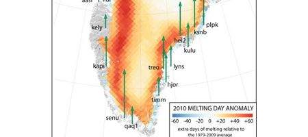
“Really, there is no other explanation,” he says. “The uplift anomaly correlates with maps of the 2010 melting day anomaly. In locations where there were many extra days of melting in 2010, the uplift anomaly is highest.”
GNET measurements indicate that as that ice melted away, the bedrock beneath it rose. The amount of uplift differed from station to station, depending on how close the station was to regions where ice loss was greatest.
Southern Greenland stations that were very close to zones of heavy ice loss rose as much as 0.79 inches over the five months. Even stations that were located far away typically rose at least 5 mm 0.2 inches. during the course of the 2010 melting season.