Last October’s Superstorm Sandy was made far worse by the melting of Arctic sea ice, new research suggests.
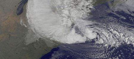
Sea ice loss in the region hit record levels in summer 2012. And, say Cornell and Rutgers researchers, this loss – attributed to global warming – appears to have ramped up the meandering of the Northern Hemisphere jet stream.
This intensifies Arctic air mass invasions toward middle latitudes – and increases the frequency of atmospheric blocking events like the one that steered Hurricane Sandy west into New York.
It’s this strong, high-pressure blocking pattern over Greenland and the northwest Atlantic that stopped Hurricane Sandy from traveling northeast and out to sea, like most October hurricanes and tropical storms from the Caribbean.
Instead, it moved up the Atlantic coast and veered left toward New York, where it converged with an extratropical cyclone, feeding the weakening Hurricane Sandy and transforming it into a superstorm.
Sandy’s extremely low atmospheric pressure and the strong high-pressure block to the north created violent east winds that pushed storm surge against the eastern seaboard.
“To literally top it off, the storm surge combined with full-moon high tides and huge ocean waves to produce record high water levels that exceeded the worst-case predictions for parts of New York City,” write the researchers.
“If one accepts this evidence and… takes into account the record loss of Arctic sea ice this past September, then perhaps the likelihood of greenhouse warming playing a significant role in Sandy’s evolution as an extratropical superstorm is at least as plausible as the idea that this storm was simply a freak of nature.”